Practice showed that in a certain number of cases the combination of the two does work when using a special driver. Unfortunately the compatibility depends on a specific combination of hardware, software and settings which can not be generalized.
Plaxis is equipped with features to deal with various aspects of complex geotechnical structures.
Main features:
Interfaces
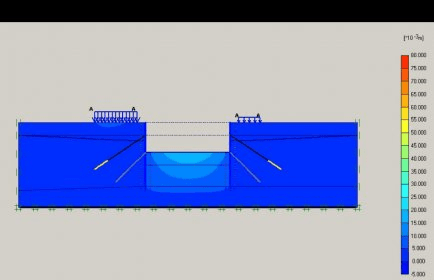
Joint elements are available to model soil structure interaction. For example, these elements may be used to simulate the thin zone of intensely shearing material at the contact between a tunnel lining and the surrounding soil. Values of interface friction angle and adhesion are generally not the same as the friction angle and cohesion of the surrounding soil.
Geogrids
Geogrids (or geotextiles) are often used in practice for the construction of reinforced embankments or soil retaining structures. These elements can be simulated in Plaxis by the use of special tension elements. It is often convenient to combine these elements with interfaces to model the interaction with the surrounding soil.
Anchors
Elastoplastic spring elements are used to model anchors and struts. The behaviour of these elements is defined using an axial stiffness and a maximum force. A special option exists for the analyses of pre-stressed ground anchors and excavation supports.
Boundary conditions more

Comments